

That makes these locations interesting to investigate rather than automatically labeling them supernatural. Grab your computer or phone, open Google Earth, and use the coordinates below to explore some of the world’s eeriest locations from a safe distance.
What Makes a Place Scary on Google Earth?
A location does not need to be haunted to look disturbing from above. Abandoned buildings, empty streets, unusual formations, remote islands, military facilities, and areas associated with disasters can all create an eerie impression.
Google Earth also lets users zoom into available Street View imagery and, where available, explore historical imagery. Google says historical imagery can show how locations have changed over time, while historical Street View allows users to explore street-level imagery from different periods.
With that in mind, the following list focuses on places that are genuinely unusual, visually unsettling, historically significant, or especially atmospheric when explored virtually.
15 Scary Places to Visit on Google Earth
1. Hashima Island, Japan
Coordinates: 32.6278, 129.7381
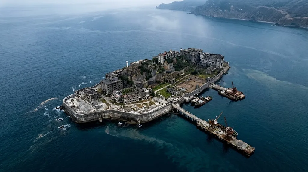
Hashima Island, also known as Gunkanjima or Battleship Island, is one of the most atmospheric abandoned locations you can explore online. The small island near Nagasaki was once a thriving coal-mining community. After the mine closed in 1974, the island was abandoned.
Today, dense concrete buildings, empty structures, and a surrounding seawall give Hashima an unmistakably ghost-town appearance. Japan’s official tourism organization describes it as an eerie former coal mine and notes that the island is now a tourist attraction, although access requires an organized tour because of structural instability.
Google Arts & Culture has also documented Hashima through Street View, making it one of the most interesting abandoned places to explore virtually.
2. Pripyat Amusement Park, Ukraine
Coordinates: 51.4079, 30.0553
The abandoned amusement park in Pripyat is one of the most recognizable eerie locations associated with Google Earth. Its Ferris wheel and deserted surroundings have become powerful visual symbols of the abandoned city.
Pripyat was evacuated following the 1986 Chernobyl nuclear disaster. The empty amusement park is especially unsettling because it was built for ordinary recreation but never experienced the future it was designed for.
Virtual exploration is the sensible option for most people. The Chornobyl Nuclear Power Plant’s official visitor information states that access to the exclusion zone requires authorization and can be restricted because of safety, weather, emergency, and operational conditions.
3. The Boneyard, Arizona
Coordinates: 32.1709, -110.8552
Thousands of retired aircraft arranged across the Arizona desert create an image that can look almost surreal from above. The site is the 309th Aerospace Maintenance and Regeneration Group, commonly known as the Boneyard, at Davis-Monthan Air Force Base in Tucson.
The U.S. Department of Defense describes the facility as the world’s largest aircraft storage and preservation facility, with thousands of aircraft and engines.
Despite its nickname, the Boneyard is not a mysterious graveyard. The aircraft are stored, preserved, reclaimed for parts, or potentially returned to service. It is also a controlled military facility rather than an ordinary tourist attraction.
4. Duga Radar, Ukraine
Coordinates: 51.3056, 30.0647
Near the Chernobyl area stands the enormous Duga radar installation, a Cold War-era structure that looks particularly strange when viewed from above.
The giant metal array was part of a Soviet over-the-horizon radar system. Its immense scale, remote surroundings, and association with the Cold War give it an unsettling appearance.
It is a good example of why some scary-looking Google Earth locations have ordinary historical explanations. What appears mysterious from a satellite view can become much more understandable once the site’s history is known.
5. The Island of the Dolls, Mexico
Coordinates: 19.2900, -99.0953
South of Mexico City in the canals of Xochimilco is the famous Isla de las Muñecas, or Island of the Dolls. The location became known for dolls and doll parts displayed around the island, creating one of the most disturbing visual atmospheres associated with the area.
The story surrounding the island involves a man named Don Julián Santana Barrera and a drowned girl whose spirit he believed remained nearby. Much of the supernatural story is based on local legend rather than independently verified evidence.
That distinction makes the location even more interesting to explore: the frightening appearance is real, while claims about supernatural activity should be treated as folklore rather than established fact.
6. Teufelsberg Listening Station, Germany
Coordinates: 52.4975, 13.2419
On an artificial hill in Berlin sits Teufelsberg, a former listening station recognizable by its distinctive white radar domes. The combination of abandoned infrastructure, unusual architecture, and elevated woodland surroundings gives the location an eerie appearance.
Teufelsberg is particularly interesting for people who enjoy abandoned Cold War sites. From Google Earth, the domes and surrounding landscape provide a striking perspective that is difficult to appreciate from an ordinary street map.
7. Maunsell Sea Forts, England
Coordinates: 51.4827, 1.0479
Standing offshore in the Thames Estuary, the Maunsell Sea Forts look like strange metal structures rising from the water. Their isolated position and weathered appearance make them a natural choice for a creepy Google Earth search.
The forts were constructed as wartime defensive structures. Their unusual arrangement becomes much clearer when viewed from above, while their isolation creates the atmosphere that makes them seem mysterious.
Because these structures are offshore and can be hazardous, virtual exploration is preferable unless you have a legitimate reason and appropriate arrangements for physical access.
8. Area 51, Nevada
Coordinates: 37.2431, -115.7930
Area 51 has become one of the world’s most famous locations for conspiracy theories, making it an obvious choice for anyone searching for creepy or mysterious places on Google Earth.
The attraction is not that Google Earth reveals an extraterrestrial secret. Instead, the remote desert setting, restricted military environment, runways, and decades of popular speculation make the location fascinating to examine from above.
For the best experience, zoom out first to understand the surrounding desert landscape before moving closer to the visible infrastructure.
9. The Maunsell Forts and Other Isolated Offshore Structures
Some of the creepiest Google Earth discoveries are not famous because of a particular legend. They simply look unnatural in their environment.
Offshore structures are a perfect example. Isolated towers surrounded by open water can appear almost like scenes from a science-fiction film when viewed from satellite imagery.
These locations demonstrate why satellite exploration can be so compelling: perspective changes the way familiar types of structures are perceived.
10. Snake Island, Brazil
Location: Ilha da Queimada Grande, São Paulo state, Brazil
Ilha da Queimada Grande is better known as Snake Island because of its reputation for having a large population of venomous snakes. The island’s isolation and reputation make it an obvious candidate for a virtual exploration list.
Unlike some internet mysteries, the danger associated with the island is not simply a scary story. Access is restricted because of legitimate safety and conservation concerns.
Google Earth offers a way to appreciate the island’s remote setting without putting yourself in an unsafe environment.
11. Fly Geyser, Nevada
Coordinates: 40.8597, -119.3318
Fly Geyser does not look like a conventional scary place, but its bizarre colors and unusual geothermal formations can appear otherworldly when seen from above.
The vivid mineral deposits and towering formations stand out dramatically against Nevada’s desert landscape. It is a good reminder that “scary” on Google Earth can sometimes mean strange, alien-looking, or visually unsettling rather than genuinely dangerous.
12. The Duga Radar Surroundings
The wider landscape around the Duga radar installation deserves attention because of its relationship with the Chernobyl exclusion area.
Remote forests, abandoned infrastructure, and Cold War installations create a combination that can feel like the setting of a post-apocalyptic film. Exploring the area virtually also allows you to examine the landscape without confusing digital exploration with permission to enter restricted areas.
13. Abandoned Concrete Settlements and Industrial Ruins on Hashima
Hashima is worth revisiting from different angles because the island’s architecture changes dramatically depending on your viewpoint.
From above, its compact layout makes the island look almost artificial. At street level, the abandoned buildings reveal a much more detailed picture of what happened after the community disappeared.
Google’s Street View coverage is especially useful here because it allows virtual visitors to see parts of the island that are difficult to understand from a single satellite image.
14. Remote Military Installations
Google Earth contains countless military facilities that can appear mysterious because of their remote locations, unusual layouts, or restricted status.
However, users should be careful about treating unusual satellite imagery as evidence of secret activity. A strange building or geometric pattern can have a perfectly ordinary military, industrial, or scientific purpose.
That uncertainty is part of the fun: you can investigate what is visible without turning an unexplained image into an unsupported conspiracy.
15. Strange Satellite Imagery and Unexplained Shapes
Some of the scariest things you can find on Google Earth are not places with dark histories at all. They are strange shapes created by perspective, shadows, image stitching, natural formations, agricultural patterns, or unusual infrastructure.
Google explains that its imagery is assembled from photographs collected across different periods, and the date shown may not represent one single moment for an entire view.
This means an unusual image deserves investigation before it is described as paranormal or unexplained.
How to Find Scary Places on Google Earth
Finding unusual locations is easier when you combine coordinates with different viewing tools. Google Earth lets you search for a location directly, zoom in, and use Street View where imagery is available.
- Open Google Earth: Use the web version or the Google Earth app.
- Search the location: Paste a place name or latitude and longitude into the search field.
- Start from a wider view: Zoom out first so you understand the location’s surrounding geography.
- Switch to Street View when available: Select a highlighted area to explore street-level imagery.
- Check historical imagery: When available, use the historical imagery timeline to compare different periods.
- Research the location: Look for reliable information before assuming that an unusual image has a supernatural explanation.
Can You See Everything in Google Earth?
No. Google Earth does not provide a live, unrestricted view of every location on Earth.
Coverage varies, and Street View imagery is only available in certain areas. Google also notes that satellite and aerial imagery can come from different dates and sources.
Some places may therefore look different from what you see in recent photographs, while other locations may not have Street View coverage at all.
Why Scary Google Earth Images Can Be Misleading
Viral screenshots can make ordinary locations appear mysterious. Shadows can resemble figures, image stitching can create unusual shapes, and old imagery can show objects or structures that have since changed.
Historical imagery is particularly important when investigating unusual discoveries. Google Earth provides a timeline that allows users to compare imagery from different periods where historical coverage exists.
Instead of immediately believing that a strange image represents a hidden secret, compare dates, change the viewing angle, zoom out, and research the location’s documented history.
Are These Places Actually Haunted?
Not necessarily. “Scary” is often a description of the atmosphere, appearance, or reputation of a location rather than evidence of paranormal activity.
Hashima is genuinely abandoned, Pripyat is genuinely associated with the Chernobyl disaster, and the Boneyard genuinely contains thousands of retired aircraft. Those facts alone can make a place fascinating without requiring supernatural explanations.
For locations surrounded by legends, such as the Island of the Dolls, it is useful to separate documented history from folklore. Doing so makes the exploration more interesting and prevents sensational claims from being presented as established facts.
Tips for Exploring Creepy Places Safely
- Explore virtually first: Google Earth is ideal for viewing remote and restricted locations without physically entering them.
- Respect restricted areas: A location appearing on a map does not mean that visitors are legally permitted to enter.
- Check official information: Access rules can change, particularly around military, industrial, and protected areas.
- Do not trespass: Abandoned-looking buildings can still be privately owned or structurally dangerous.
- Question viral claims: Investigate unusual images instead of assuming every strange shape is paranormal.
Other Interesting Places to Explore Online
If you enjoy unusual destinations, you can continue exploring the world’s strangest travel locations through our guide to the best haunted places to visit in London. For a broader travel list, our guide to places to visit around the world offers a completely different type of virtual exploration.
Final Thoughts
The scary places to visit on Google Earth are often the locations that make you stop, zoom in, and ask what you are actually looking at. Abandoned islands, deserted cities, military installations, strange landscapes, and unusual satellite imagery can all provide hours of virtual exploration.
The most interesting approach is to combine curiosity with skepticism. Explore the imagery, check historical views, research the location, and separate documented facts from legends. Google Earth is not a supernatural detector, but it is an extraordinary way to investigate some of the world’s strangest and most atmospheric places from almost anywhere.